
ملف:De facto cantons of Rojava.png

حجم هذه المعاينة: 725 × 599 بكسل. الأبعاد الأخرى: 290 × 240 بكسل | 581 × 480 بكسل | 929 × 768 بكسل | 1٬239 × 1٬024 بكسل | 2٬000 × 1٬653 بكسل.
الملف الأصلي (2٬000 × 1٬653 بكسل حجم الملف: 268 كيلوبايت، نوع MIME: image/png)
| هذا ملف من ويكيميديا كومنز. معلومات من صفحة وصفه مبينة في الأسفل. كومنز مستودع ملفات ميديا ذو رخصة حرة. |

|
هذه map الصورة / الصورتان باستعمال رسومات متجهية ملفات رسوميات شعاعية.
It is recommended to name the SVG file "De facto cantons of Rojava.svg" - then the template Vector version available (or Vva) does not need the new image name parameter.
|
ملخص
| الوصف |
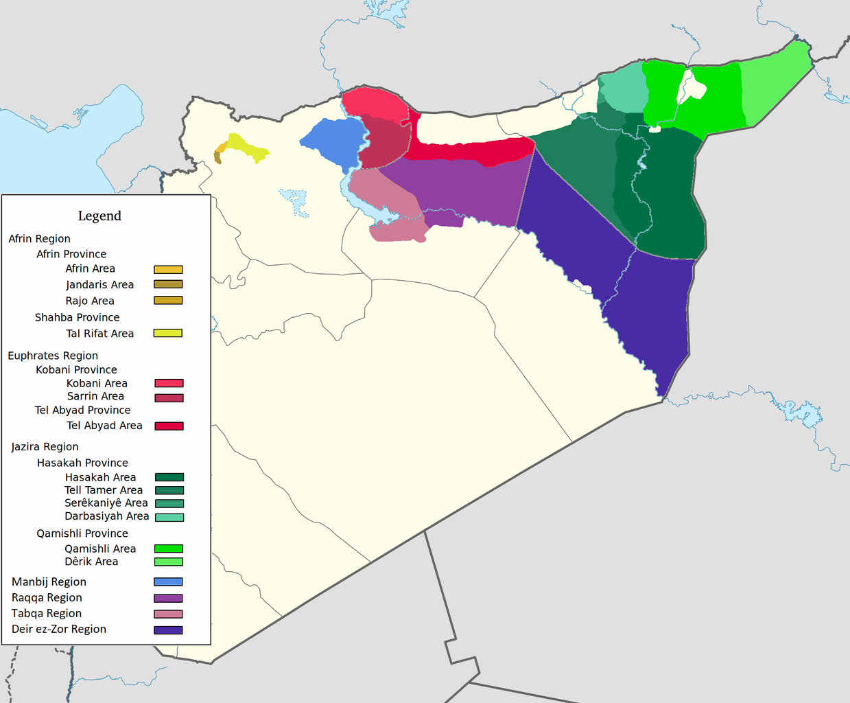
العربية: اقليم عفرين اقليم الفرات اقليم الجزيرة English: Afrin Region Euphrates Region Jazeera Region No region 한국어: 아프린 주 유프라테스 주 자제라 주 없음 |
| التاريخ | |
| المصدر | عمل شخصي |
| المؤلف | Editor abcdef |
| إصدارات أخرى |
 |
ترخيص
أنا، صاحب حقوق التأليف والنشر لهذا العمل، أنشر هذا العمل تحت الرخصة التالية:
هذا الملفُّ مُرخَّص بموجب رخصة المشاع الإبداعي نسبة المُصنَّف إِلى مُؤَلِّفه - المشاركة بالمثل 3.0 العامة
- يحقُّ لك:
- مشاركة العمل – نسخ العمل وتوزيعه وبثُّه
- إعادة إنتاج العمل – تعديل العمل
- حسب الشروط التالية:
- نسب العمل إلى مُؤَلِّفه – يلزم نسب العمل إلى مُؤَلِّفه بشكل مناسب وتوفير رابط للرخصة وتحديد ما إذا أجريت تغييرات. بالإمكان القيام بذلك بأية طريقة معقولة، ولكن ليس بأية طريقة تشير إلى أن المرخِّص يوافقك على الاستعمال.
- الإلزام بترخيص المُشتقات بالمثل – إذا أعدت إنتاج المواد أو غيرت فيها، فيلزم أن تنشر مساهماتك المُشتقَّة عن الأصل تحت ترخيص الأصل نفسه أو تحت ترخيص مُتوافِقٍ معه.
تاريخ الملف
اضغط على زمن/تاريخ لرؤية الملف كما بدا في هذا الزمن.
| زمن/تاريخ | صورة مصغرة | الأبعاد | مستخدم | تعليق | |
|---|---|---|---|---|---|
| حالي | 08:29، 27 مايو 2020 | | 2٬000 × 1٬653 (268 كيلوبايت) | AntonSamuel | Reverted to version as of 09:02, 8 April 2020 (UTC) Restoring original map without stripes per COM:OW and discussion on the Rojava talk page on Wikipedia |
| 09:05، 8 أبريل 2020 |  | 2٬000 × 1٬653 (224 كيلوبايت) | Bill497 | Reverted to version as of 08:59, 8 April 2020 (UTC) Revert vandalism. | |
| 09:02، 8 أبريل 2020 |  | 2٬000 × 1٬653 (268 كيلوبايت) | AntonSamuel | Reverted to version as of 08:51, 8 April 2020 (UTC) Third, and last warning given on user talk page. | |
| 08:59، 8 أبريل 2020 |  | 2٬000 × 1٬653 (224 كيلوبايت) | Bill497 | Reverted to version as of 08:11, 8 April 2020 (UTC) Revert vandalism for a 3rd time. User is reverting a referenced map to an unreferenced version. | |
| 08:51، 8 أبريل 2020 |  | 2٬000 × 1٬653 (268 كيلوبايت) | AntonSamuel | Reverted to version as of 17:57, 7 April 2020 (UTC) Once again, use the Rojava talk page to discuss before making reverts and don't throw around unfounded vandalism claims. Second warning on talk page given. | |
| 08:11، 8 أبريل 2020 |  | 2٬000 × 1٬653 (224 كيلوبايت) | Bill497 | Reverted to version as of 11:10, 7 April 2020 (UTC) Revert vandalism. | |
| 17:57، 7 أبريل 2020 |  | 2٬000 × 1٬653 (268 كيلوبايت) | AntonSamuel | Reverted to version as of 00:50, 7 April 2020 (UTC) Restoring viewable version - Use Rojava talk page, warning left on user talk page | |
| 11:10، 7 أبريل 2020 |  | 2٬000 × 1٬653 (224 كيلوبايت) | Bill497 | Reverted to version as of 12:33, 2 April 2020 (UTC) Revert attempted vandalism into a factually incorrect version of the map. SDF has entirely no presence in some of the dashed zones. Due to fog of war these areas are all displaced as mixed with government control. Russia is the only reliable source displaying where the government is present. | |
| 00:50، 7 أبريل 2020 |  | 2٬000 × 1٬653 (268 كيلوبايت) | AntonSamuel | Continuation from below: ...manner. Further sources are needed apart from the Russian military maps - they cannot be considered to be neutral or factually accurate without additional verification. | |
| 00:46، 7 أبريل 2020 |  | 2٬000 × 1٬653 (218 كيلوبايت) | AntonSamuel | Clearing the 50/50 paint because of the visual difficulty and for deviation from the main purpose of this map - which is to display the various subregions of the civilian administration of the de facto autonomous region, not military control agreements such as SDF-SAA/Russia and SDF-US/US-led coalition which have no known civilian aspect as of date. Please discuss the issue first and foremost on the Rojava talk page if areas with an SAA/Russian or a US presence need to be highlighted in some... |
استخدام الملف
الصفحة التالية تستخدم هذا الملف:
الاستخدام العالمي للملف
الويكيات الأخرى التالية تستخدم هذا الملف:
- الاستخدام في arz.wikipedia.org
- الاستخدام في azb.wikipedia.org
- الاستخدام في ca.wikipedia.org
- الاستخدام في diq.wikipedia.org
- الاستخدام في fa.wikipedia.org
- الاستخدام في glk.wikipedia.org
- الاستخدام في id.wikipedia.org
- الاستخدام في ku.wikipedia.org
- الاستخدام في nl.wikipedia.org
- الاستخدام في ru.wikipedia.org
- الاستخدام في tr.wikipedia.org
- الاستخدام في vi.wikipedia.org
- الاستخدام في www.wikidata.org
- الاستخدام في zh.wikipedia.org