
ملف:Ghajar highlighted.JPG
حجم هذه المعاينة: 517 × 599 بكسل. الأبعاد الأخرى: 207 × 240 بكسل | 414 × 480 بكسل | 742 × 860 بكسل.
الملف الأصلي (742 × 860 بكسل حجم الملف: 108 كيلوبايت، نوع MIME: image/jpeg)
| هذا ملف من ويكيميديا كومنز. معلومات من صفحة وصفه مبينة في الأسفل. كومنز مستودع ملفات ميديا ذو رخصة حرة. |
| الوصف |
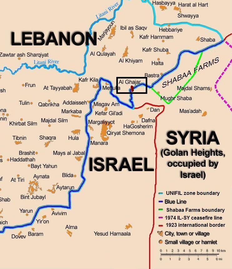
English: Map showing the Blue Line demarcation line between Lebanon and Israel, established by the UN after the Israeli withdrawal from southern Lebanon after its short 1978 invasion called "Operation Litani". It follows the 1949 cease-fire line, also known as the Green Line, as well as the somewhat contested Lebanese-Syrian border towards the Israeli-occupied Golan Heights. The map is made by Thomas Blomberg, using the UNIFIL map, deployment as of July 2006 as source. Español: Sumario. Mapa mostrando a la línea de demarcación de Línea Azul entre Líbano y Israel, establecido por las Naciones Unidas después de la retirada israelí de Líbano del sur después de su invasión de 1978 corta llamada " Operación Litani ". Esto sigue la línea de alto el fuego 1949, también sabida(conocida) como la Línea Verde, así como la frontera algo impugnada libanesa siria hacia Altos del Golán Ocupados por israelí. El mapa es hecho por Thomas Blomberg, usando el mapa de UNIFIL, el despliegue desde el julio de 2006 como la fuente |
| التاريخ | (UTC) |
| المصدر | |
| المؤلف |
|
| هذا رسمٌ مُعَدَّلٌ رقميَّاً من النسخة الأصليَّة. التعديلات هي: zoom, highlight Ghajar. يُمكن الاطلاع على النسخة الأصليَّة هنا: BlueLine.jpg:
|
أنا، صاحب حقوق التأليف والنشر لهذا العمل، أنشر هذا العمل تحت الرخصة التالية:
هذا الملف مُرخص تحت رخصة المشاع المبدع نسبة المصنف إلى مؤلفه - المشاركة على قدم المساواة 2.5 العامة
- يحقُّ لك:
- مشاركة العمل – نسخ العمل وتوزيعه وبثُّه
- إعادة إنتاج العمل – تعديل العمل
- حسب الشروط التالية:
- نسب العمل إلى مُؤَلِّفه – يلزم نسب العمل إلى مُؤَلِّفه بشكل مناسب وتوفير رابط للرخصة وتحديد ما إذا أجريت تغييرات. بالإمكان القيام بذلك بأية طريقة معقولة، ولكن ليس بأية طريقة تشير إلى أن المرخِّص يوافقك على الاستعمال.
- الإلزام بترخيص المُشتقات بالمثل – إذا أعدت إنتاج المواد أو غيرت فيها، فيلزم أن تنشر مساهماتك المُشتقَّة عن الأصل تحت ترخيص الأصل نفسه أو تحت ترخيص مُتوافِقٍ معه.
سجلُّ الرَّفع الأصيل
This image is a derivative work of the following images:
- File:BlueLine.jpg licensed with Cc-by-sa-2.5
- 2010-02-15T10:27:00Z Ynhockey 1299x898 (160308 Bytes) Boundery?[sic] Anyway, this is the international border. If you want to draw the DMZ, make an extra line, but please do it with an app other than MSPaint
- 2008-08-10T03:01:31Z Drork 1299x898 (160308 Bytes) == Summary == Map showing the [[Blue Line (Lebanon)|Blue Line]] demarcation line between [[Lebanon]] and [[Israel]], established by the [[United Nations|UN]] after the Israeli withdrawal from southern Lebanon after its short
- 2006-08-17T16:30:36Z Thomas Blomberg 1299x898 (244059 Bytes)
- 2006-08-04T14:16:01Z Thomas Blomberg 1299x898 (658281 Bytes) Map showing the Blue Line demarkation line between Lebanon and Israel, established by the UN after the Israeli withdrawal from southern Lebanon after its short 1978 invasion called "Operation Litani". It follows the 1949 ceas
Uploaded with derivativeFX
تاريخ الملف
اضغط على زمن/تاريخ لرؤية الملف كما بدا في هذا الزمن.
| زمن/تاريخ | صورة مصغرة | الأبعاد | مستخدم | تعليق | |
|---|---|---|---|---|---|
| حالي | 20:20، 21 أكتوبر 2010 | | 742 × 860 (108 كيلوبايت) | Nableezy | change map base, highlight color |
| 19:11، 21 أكتوبر 2010 |  | 760 × 884 (110 كيلوبايت) | Nableezy | change highlight color | |
| 17:59، 21 أكتوبر 2010 |  | 809 × 868 (116 كيلوبايت) | Nableezy | {{Information |Description={{en|Map showing the Blue Line demarcation line between Lebanon and Israel, established by the UN after the Israeli withdrawal from southern Lebanon after its short 1978 invas |
استخدام الملف
الصفحة التالية تستخدم هذا الملف:
الاستخدام العالمي للملف
الويكيات الأخرى التالية تستخدم هذا الملف:
- الاستخدام في ca.wikipedia.org
- الاستخدام في de.wikipedia.org
- الاستخدام في eo.wikipedia.org
- الاستخدام في fi.wikipedia.org
- الاستخدام في fr.wikipedia.org
- الاستخدام في nl.wikipedia.org
- الاستخدام في pl.wiktionary.org
- الاستخدام في www.wikidata.org