
ملف:Global carbon dioxide AIRS.jpg
لا توجد دقة أعلى متوفرة.
Global_carbon_dioxide_AIRS.jpg (496 × 392 بكسل حجم الملف: 28 كيلوبايت، نوع MIME: image/jpeg)
| هذا ملف من ويكيميديا كومنز. معلومات من صفحة وصفه مبينة في الأسفل. كومنز مستودع ملفات ميديا ذو رخصة حرة. |
ملخص
| الوصف |
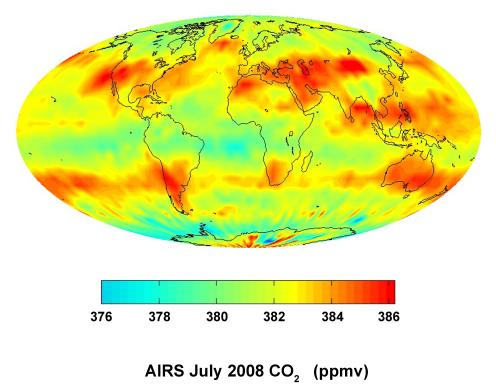
English: This global satellite map shows carbon dioxide in the mid-troposphere, about 8 kilometers above Earth. It was created with data acquired by the Atmospheric Infrared Sounder (AIRS) instrument during July 2008.
The distribution of carbon dioxide in this region of the atmosphere is strongly influenced by major surface sources of carbon dioxide and by large-scale atmospheric circulation patterns, such as the jet streams and weather systems in Earth's mid-latitudes. Patterns of carbon dioxide distribution differ significantly between the northern hemisphere, with its many land masses, and the southern hemisphere, which is largely covered by ocean. AIRS is one of six instruments flying on NASA's Aqua satellite. English: Carte satellitale mondiale montrant le taux moyen de dioxyde de carbone dans la mi-troposphère (+/-8 kilomètres au-dessus du niveau de la mer). Sa distribution à cette altitude est encore très influencée par les sources de surface mais elle subit aussi les grands courants de circulation atmosphérique (jets et systèmes météorologiques actifs aux latitudes moyennes de la Terre). Les schémas de distribution du CO2 diffèrent considérablement entre l'hémisphère nord, avec ses nombreuses masses terrestres très anthropisées, et l'hémisphère sud, plus largement recouvert par l'océan. Données acquises par l'instrument Atmospheric Infrared Sounder (AIRS) en juillet 2008 ; AIRS est l'un des six instruments embarqués sur le satellite Aqua de la NASA |
| التاريخ | |
| المصدر | http://photojournal.jpl.nasa.gov/catalog/PIA11194 |
| المؤلف | NASA/JPL |
فُهرِست هذه الصُّورة أَو هذا التَّسجيل المرئي لدى Jet Propulsion Laboratory التَّابعة لوكالة الفضاء الأَمريكيَّة (ناسا) تحت المُعرِّف PIA11194. لا يُشير هذه الوَسم إلى حالة حقوق التَّأليف والنَّشر الخاصَّة بالعمل المُرفَق؛ لا يزال وَسم حقوق التَّأليف والنَّشر مَطلُوباً، راجع كومنز:ترخيص لمزيدٍ من المعلومات. لغات أخرى:
|


ترخيص
| يقع هذا العمل في النِّطاق العامّ في الولايات المُتحدة الأمريكيَّة لأَنَّه عملٌ خالِصٌ من إِنتاج وكالة الفضاء الأمريكيَّة. تنصُ حقوق التَّأليف والنَّشر الخاصَّة بوكالة الفضاء الأمريكيَّة على أنَّ "أعمال الوكالة غير مَحميَّة بحقوق التَّأليف والنَّشر ما لم يُذكر خلافُ ذلك". لمزيدٍ من المعلومات انظر القالِب {{PD-USGov}} وصفحة حقوق التَّأليف والنَّشر الخاصَّة بالوكالة وصفحة سياسة الصُّور الخاصَّة بمُختبر الدَّفع النَّفَّاث. | ||
 |
تنبيهات:
|
تاريخ الملف
اضغط على زمن/تاريخ لرؤية الملف كما بدا في هذا الزمن.
| زمن/تاريخ | صورة مصغرة | الأبعاد | مستخدم | تعليق | |
|---|---|---|---|---|---|
| حالي | 21:23، 9 مارس 2012 | | 496 × 392 (28 كيلوبايت) | Ras67 | losslessly cropped with Jpegcrop |
| 17:16، 25 أكتوبر 2008 |  | 666 × 500 (31 كيلوبايت) | Maddox1 | {{Information |Description={{en|1=This global satellite map shows carbon dioxide in the mid-troposphere, about 8 kilometers above Earth. It was created with data acquired by the Atmospheric Infrared Sounder (AIRS) instrument during July 2008. The di |
استخدام الملف
الصفحة التالية تستخدم هذا الملف:
الاستخدام العالمي للملف
الويكيات الأخرى التالية تستخدم هذا الملف:
- الاستخدام في de.wikipedia.org
- الاستخدام في de.wikiversity.org
- الاستخدام في en.wikipedia.org
- الاستخدام في en.wikibooks.org
- الاستخدام في fr.wikipedia.org
- الاستخدام في fr.wikiversity.org
- الاستخدام في no.wikipedia.org
- الاستخدام في vi.wikipedia.org