
ملف:Larose Louisiana aerial view.jpg

حجم هذه المعاينة: 800 × 533 بكسل. الأبعاد الأخرى: 320 × 213 بكسل | 640 × 427 بكسل | 1٬024 × 683 بكسل | 1٬500 × 1٬000 بكسل.
الملف الأصلي (1٬500 × 1٬000 بكسل حجم الملف: 278 كيلوبايت، نوع MIME: image/jpeg)
| هذا ملف من ويكيميديا كومنز. معلومات من صفحة وصفه مبينة في الأسفل. كومنز مستودع ملفات ميديا ذو رخصة حرة. |
| الوصف |
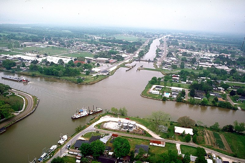
English: Aerial view of the intersection of Bayou Lafourche and the Gulf Intracoastal Waterway at Larose, Louisiana, USA. The waterway runs left–right across the photograph and the bayou runs off into the distance at the top. The U.S. Army Corps of Engineers has installed a floodgate on the bayou, visible at center. |
|||
| التاريخ | ||||
| المصدر |
U.S. Army Corps of Engineers Digital Visual Library Image page Image description page Digital Visual Library home page |
|||
| المؤلف | Arthur Belala, U.S. Army Corps of Engineers | |||
| الترخيص (إعادة استخدام هذا الملف) |
|
|||
| الموقع | Larose, Louisiana, USA |
| موقع الكاميرا | | هذه وغيرها من الصور في مواقعها على: خريطة الشارع المفتوحة |
|---|
تاريخ الملف
اضغط على زمن/تاريخ لرؤية الملف كما بدا في هذا الزمن.
| زمن/تاريخ | صورة مصغرة | الأبعاد | مستخدم | تعليق | |
|---|---|---|---|---|---|
| حالي | 16:28، 1 أبريل 2007 | | 1٬500 × 1٬000 (278 كيلوبايت) | DanMS | {{Information | Description = {{en|Aerial view of the intersection of Bayou Lafourche and the Gulf Intracoastal Waterway at Larose, Louisiana, USA. The bayou runs left–right across the photograph and the waterway runs off into the distance at the top |
استخدام الملف
الصفحة التالية تستخدم هذا الملف:
الاستخدام العالمي للملف
الويكيات الأخرى التالية تستخدم هذا الملف:
- الاستخدام في azb.wikipedia.org
- الاستخدام في ca.wikipedia.org
- الاستخدام في ceb.wikipedia.org
- الاستخدام في ce.wikipedia.org
- الاستخدام في de.wikipedia.org
- الاستخدام في en.wikipedia.org
- الاستخدام في es.wikipedia.org
- الاستخدام في fa.wikipedia.org
- الاستخدام في fr.wikipedia.org
- الاستخدام في it.wikipedia.org
- الاستخدام في ja.wikipedia.org
- الاستخدام في lld.wikipedia.org
- الاستخدام في pl.wikipedia.org
- الاستخدام في pt.wikipedia.org
- الاستخدام في sh.wikipedia.org
- الاستخدام في sr.wikipedia.org
- الاستخدام في tt.wikipedia.org
- الاستخدام في uk.wikipedia.org
- الاستخدام في www.wikidata.org
- الاستخدام في zh-min-nan.wikipedia.org
- الاستخدام في zh.wikipedia.org