
ملف:Morrison Formation from near Notom-Bullfrog Road in southern Capitol Reef National Park.jpg
Morrison_Formation_from_near_Notom-Bullfrog_Road_in_southern_Capitol_Reef_National_Park.jpg (800 × 600 بكسل حجم الملف: 497 كيلوبايت، نوع MIME: image/jpeg)
| هذا ملف من ويكيميديا كومنز. معلومات من صفحة وصفه مبينة في الأسفل. كومنز مستودع ملفات ميديا ذو رخصة حرة. |
ملخص
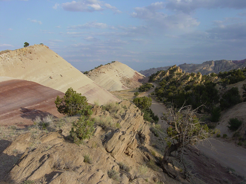
USGS photo from [1] Red and gray shale of the Morrison Formation form from volcanic ash deposited an a broad coastal floodplain during the Jurassic Period (between 208 and 144 million years ago). The sand bed in the foreground probably represent old stream channel deposits. When the sediments were originally deposited they were nearly flat lying, but the tectonic forces that shaped the Waterpocket Fold in the Tertiary Period resulted in the rock layers dipping steeply to the left. These outcrops are along the Notom-Bullfrog Road in southern Capitol Reef National Park.
ترخيص
تقع هذه الصُّورة في النِّطاق االعامِّ في الولايات المُتحدة الأَمريكيَّة لأَنَّها عملٌ أُعدَّ مِن ضابطٍ أَو مُوظَّفٍ في الحكومة الاتحاديَّة للولايات المُتحدة في أَثناء قيامه بواجباته الرَّسميَّة، انظر في البند 17 الفصلَ 1 وفيه القسم 105 من قانون الولايات المُتحدة الأمريكيَّة.
ملاحظة: ينطبق هذا فقط على الأعمال الأصيلة للحكومة الاتحادية وليس على أعمال الولايات أو التبعيات فُرادى ولا على أَيِّ تقسيماتٍ إِداريَّةٍ أُخرى. لا ينطبق هذا القالب أيضاً على على تصاميم الطَّوابع البريديَّة الَّتي نَشرتها الخدمة البريدية للولايات المتحدة منذ العام 1978م. (انظر § 313.6(C)(1) مِن خُلاصة الممارسات العمليَّة لمَكتب حقوق التَّأليف والنَّشر الأمريكية). ولا تَنطبق أَيضاً على بعض قطع النُّقود المعدنيَّة الأَمريكيَّة ;شروط استخدام دار سكِّ العملة الأَمريكيَّة.
|
 | |
| هذا الملفُّ مَلحُوظُ بصفته غيرَ مُقيَّدٍ بحقوق التَّأليف والنشر، وهذا يشمل أيضاً الحقوق المُجاوِرة أَو ذات الصلة جميعُها. | ||
تاريخ الملف
اضغط على زمن/تاريخ لرؤية الملف كما بدا في هذا الزمن.
| زمن/تاريخ | صورة مصغرة | الأبعاد | مستخدم | تعليق | |
|---|---|---|---|---|---|
| حالي | 02:28، 16 مارس 2006 | | 800 × 600 (497 كيلوبايت) | Mav | USGS photo from [http://3dparks.wr.usgs.gov/capitol2/html/3d068.html] Red and gray shale of the Morrison Formation form from volcanic ash deposited an a broad coastal floodplain during the Jurassic Period (between 208 and 144 million years ago). The sand |
استخدام الملف
الصفحة التالية تستخدم هذا الملف:
الاستخدام العالمي للملف
الويكيات الأخرى التالية تستخدم هذا الملف:
- الاستخدام في en.wikipedia.org
- الاستخدام في fr.wikipedia.org