
ملف:Mount Erebus craters, Ross Island, Antarctica (aerial view, 18 December 2000).jpg

حجم هذه المعاينة: 800 × 525 بكسل. الأبعاد الأخرى: 320 × 210 بكسل | 640 × 420 بكسل | 1٬024 × 672 بكسل | 1٬280 × 840 بكسل | 2٬000 × 1٬312 بكسل.
الملف الأصلي (2٬000 × 1٬312 بكسل حجم الملف: 1٫32 ميجابايت، نوع MIME: image/jpeg)
| هذا ملف من ويكيميديا كومنز. معلومات من صفحة وصفه مبينة في الأسفل. كومنز مستودع ملفات ميديا ذو رخصة حرة. |
.jpg)
ملخص
| الوصف |
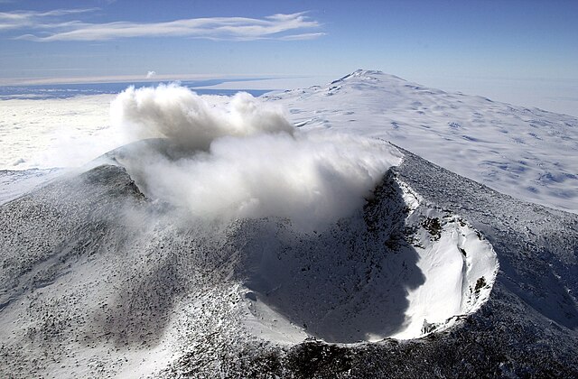
English: Aerial view of Mount Erebus craters in the foreground with Mount Terror in the background, Ross Island, Antarctica
Français : Vue aérienne des cratères du mont Erebus au premier plan et du mont Terror au dernier plan, île de Ross, Antarctique |
| التاريخ | |
| المصدر | United States Antarctic Program - Antarctic Photo Library |
| المؤلف | NSF/Josh Landis, employee 1999-2001 |
ترخيص
| This image is a work of a National Science Foundation employee, taken or made as part of that person's official duties. As a work of the U.S. federal government, the image is in the public domain. |  |
تاريخ الملف
اضغط على زمن/تاريخ لرؤية الملف كما بدا في هذا الزمن.
| زمن/تاريخ | صورة مصغرة | الأبعاد | مستخدم | تعليق | |
|---|---|---|---|---|---|
| حالي | 19:09، 8 مارس 2008 | | 2٬000 × 1٬312 (1٫32 ميجابايت) | Rémih | == Summary == {{Information | Description={{en|Aerial view of Mount Erebus craters in the foreground with Mont Terror in the background, Ross Island, Antarctica}}{{fr|Vue aérienne des cratères du mont Erebus au premier plan et du mont Terror au dernier |
استخدام الملف
الصفحة التالية تستخدم هذا الملف:
الاستخدام العالمي للملف
الويكيات الأخرى التالية تستخدم هذا الملف:
- الاستخدام في de.wikipedia.org
- الاستخدام في en.wikipedia.org
- الاستخدام في en.wikivoyage.org
- الاستخدام في fr.wikipedia.org
- الاستخدام في id.wikipedia.org
- الاستخدام في ja.wikipedia.org
- الاستخدام في kw.wikipedia.org
- الاستخدام في nl.wikipedia.org
- الاستخدام في oc.wikipedia.org
- الاستخدام في sk.wikipedia.org
- الاستخدام في sv.wikipedia.org
.jpg)