
ملف:Paraná River Floodplain, Northern Argentina.jpg

الملف الأصلي (4٬288 × 2٬850 بكسل حجم الملف: 3٫8 ميجابايت، نوع MIME: image/jpeg)
| هذا ملف من ويكيميديا كومنز. معلومات من صفحة وصفه مبينة في الأسفل. كومنز مستودع ملفات ميديا ذو رخصة حرة. |
ملخص
| الوصف |
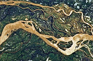
English: This astronaut photograph shows a 29-kilometre stretch of the Paraná, downstream of the small city of Goya, Argentina (just off the top left of the image).
The Paraná River ranges up to 3 kilometres wide along the reach illustrated in this image. The main channel is deep enough to allow smaller ocean-going ships to pass north to the capital city of Asunción, Paraguay, fully 1,200 kilometres inland and well out of the image. The river’s dark brown shading indicates a heavy load of muddy sediment; smaller side channels also carry this mud. Numerous lakes are typical on active floodplains, and appear here as irregular bodies of water. Some appear brown, indicating that they probably have been refilled during recent rises and floods of the active channels. The Paraná floodplain occupies the entire image; it is so wide—18 kilometres in this view—that its banks are not visible. Numerous curved, meandering channels are the most prominent characteristic of the floodplain, indicating prior positions of the river and its channels. As riverbeds move laterally by natural processes, they leave remnants of their channels, which appear as lakes and finally fill with mud. This is an excellent image for illustrating these meander forms. From a geological standpoint, it is interesting that almost all of the old channels are similar in curvature to today’s side channels. However, almost none of them seem to show prior positions of the main, wide Paraná channel. |
| التاريخ | |
| المصدر | NASA Earth Observatory |
| المؤلف | ISS Expedition 27 crew |
| موقع الكاميرا | | هذه وغيرها من الصور في مواقعها على: خريطة الشارع المفتوحة |
|---|
فُهرِست هذه الصُّورة أَو هذا التَّسجيل المرئي لدى مركز جونسون للفضاء التَّابعة لوكالة الفضاء الأَمريكيَّة (ناسا) تحت المُعرِّف ISS027-E-11058. لا يُشير هذه الوَسم إلى حالة حقوق التَّأليف والنَّشر الخاصَّة بالعمل المُرفَق؛ لا يزال وَسم حقوق التَّأليف والنَّشر مَطلُوباً، راجع كومنز:ترخيص لمزيدٍ من المعلومات. لغات أخرى:
|
Image acquired with a Nikon D2Xs digital camera using a 400 mm lens, and is provided by the ISS Crew Earth Observations experiment and Image Science & Analysis Laboratory, Johnson Space Center.
ترخيص
| يقع هذا العمل في النِّطاق العامّ في الولايات المُتحدة الأمريكيَّة لأَنَّه عملٌ خالِصٌ من إِنتاج وكالة الفضاء الأمريكيَّة. تنصُ حقوق التَّأليف والنَّشر الخاصَّة بوكالة الفضاء الأمريكيَّة على أنَّ "أعمال الوكالة غير مَحميَّة بحقوق التَّأليف والنَّشر ما لم يُذكر خلافُ ذلك". لمزيدٍ من المعلومات انظر القالِب {{PD-USGov}} وصفحة حقوق التَّأليف والنَّشر الخاصَّة بالوكالة وصفحة سياسة الصُّور الخاصَّة بمُختبر الدَّفع النَّفَّاث. | ||
 |
تنبيهات:
|
| الشروح | هذه الصورة مشروحة: أظهر الشروح في كومنز |
تاريخ الملف
اضغط على زمن/تاريخ لرؤية الملف كما بدا في هذا الزمن.
| زمن/تاريخ | صورة مصغرة | الأبعاد | مستخدم | تعليق | |
|---|---|---|---|---|---|
| حالي | 11:54، 2 مايو 2011 | | 4٬288 × 2٬850 (3٫8 ميجابايت) | Originalwana |
استخدام الملف
الصفحة التالية تستخدم هذا الملف:
الاستخدام العالمي للملف
الويكيات الأخرى التالية تستخدم هذا الملف:
- الاستخدام في de.wikipedia.org
- الاستخدام في en.wikipedia.org
- الاستخدام في eo.wikipedia.org
- الاستخدام في fa.wikipedia.org
- الاستخدام في he.wikipedia.org
- الاستخدام في ko.wikipedia.org
- الاستخدام في mk.wikipedia.org
- الاستخدام في ml.wikipedia.org
- الاستخدام في sr.wikipedia.org
- الاستخدام في uk.wikipedia.org
- الاستخدام في ur.wikipedia.org