
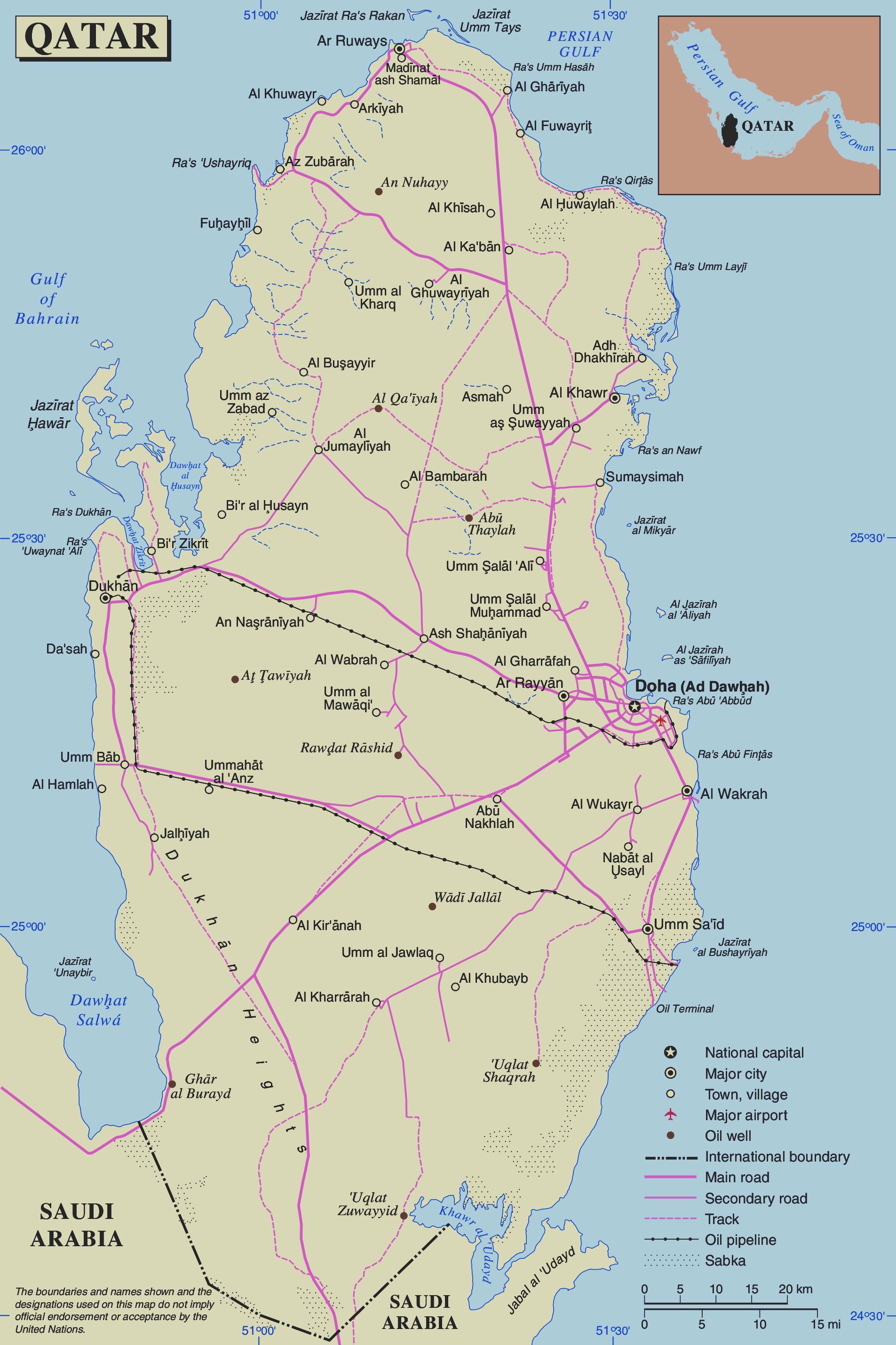
ملف:Un-qatar.png
الملف الأصلي (1٬905 × 2٬859 بكسل حجم الملف: 806 كيلوبايت، نوع MIME: image/png)
| هذا ملف من ويكيميديا كومنز. معلومات من صفحة وصفه مبينة في الأسفل. كومنز مستودع ملفات ميديا ذو رخصة حرة. |
| This image is a map derived from a United Nations map.
Unless stated otherwise, UN maps are to be considered in the public domain. This applies worldwide. UN maps are, in principle, open source material and you can use them in your work or for making your own map. UN requests however that you delete the UN name, logo and reference number upon any modification to the map. Content of your map will be your responsibility. You can state in your publication, if you wish, something like: based on UN map … (map name, map number, revision number and date). See: Geospatial Information Section. And: Geospatial, location data for a better world. |
 |
تاريخ الملف
اضغط على زمن/تاريخ لرؤية الملف كما بدا في هذا الزمن.
| زمن/تاريخ | صورة مصغرة | الأبعاد | مستخدم | تعليق | |
|---|---|---|---|---|---|
| حالي | 17:04، 24 نوفمبر 2018 | | 1٬905 × 2٬859 (806 كيلوبايت) | Sokoljan | improved contrast |
| 13:06، 25 أبريل 2011 |  | 1٬905 × 2٬859 (769 كيلوبايت) | Ras67 | cropped and squeezed | |
| 02:07، 24 أكتوبر 2007 |  | 1٬946 × 2٬900 (993 كيلوبايت) | Jeroen | {{UN map}} Category:Maps of Qatar |
استخدام الملف
الصفحة التالية تستخدم هذا الملف:
الاستخدام العالمي للملف
الويكيات الأخرى التالية تستخدم هذا الملف:
- الاستخدام في az.wikipedia.org
- الاستخدام في ca.wikipedia.org
- الاستخدام في cs.wikipedia.org
- الاستخدام في de.wikipedia.org
- الاستخدام في en.wikipedia.org
- الاستخدام في eo.wikipedia.org
- الاستخدام في fr.wikipedia.org
- الاستخدام في gom.wikipedia.org
- الاستخدام في ja.wikipedia.org
- الاستخدام في nl.wikipedia.org
- الاستخدام في pl.wiktionary.org
- الاستخدام في uk.wikipedia.org
- الاستخدام في vls.wikipedia.org