
ملف:United Kingdom United States Locator.svg

حجم معاينة PNG لذلك الملف ذي الامتداد SVG: 800 × 353 بكسل. الأبعاد الأخرى: 320 × 141 بكسل | 640 × 283 بكسل | 1٬024 × 452 بكسل | 1٬280 × 565 بكسل | 2٬560 × 1٬130 بكسل | 940 × 415 بكسل.
الملف الأصلي (ملف SVG، أبعاده 940 × 415 بكسل، حجم الملف: 2٫56 ميجابايت)
| هذا ملف من ويكيميديا كومنز. معلومات من صفحة وصفه مبينة في الأسفل. كومنز مستودع ملفات ميديا ذو رخصة حرة. |
ملخص
| الوصف |
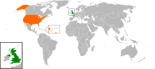
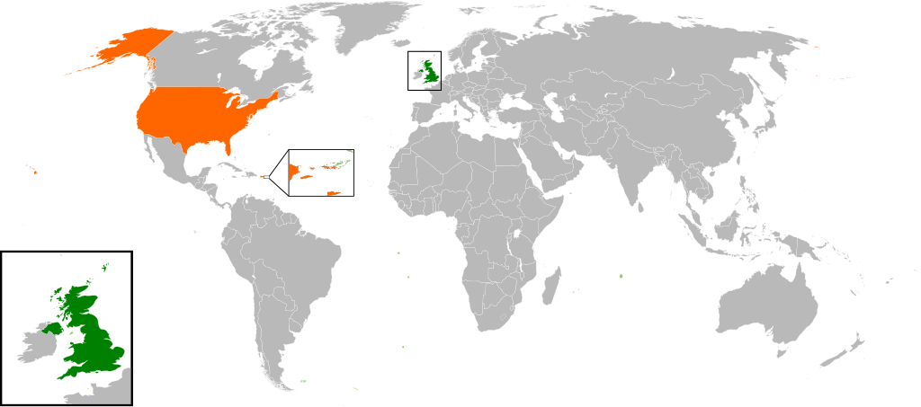
English: Map of the world showing the location of the United Kingdom and the United States of America. |
| التاريخ | |
| المصدر | عمل شخصي |
| المؤلف | Jolly Janner |
ترخيص
| أنا، مالِك حقوق تأليف ونشر هذا العمل، أجعله في النِّطاق العامِّ، يسري هذا في أرجاء العالم كلِّه. في بعض البلدان، قد يكون هذا التَّرخيص غيرَ مُمكنٍ قانونيَّاً، في هذه الحالة: أمنح الجميع حق استخدام هذا العمل لأي غرض دون أي شرط ما لم يفرض القانون شروطًا إضافية. |
تاريخ الملف
اضغط على زمن/تاريخ لرؤية الملف كما بدا في هذا الزمن.
| زمن/تاريخ | صورة مصغرة | الأبعاد | مستخدم | تعليق | |
|---|---|---|---|---|---|
| حالي | 16:00، 20 مارس 2017 | | 940 × 415 (2٫56 ميجابايت) | RaviC | add dependencies, inset map for Virgin Islands region where both states share a maritime border |
| 02:43، 24 ديسمبر 2016 |  | 940 × 415 (1٫79 ميجابايت) | BurritoBazooka | put all Faroe islands except Suðuroy region behind black border of UK box. Make two boxes (transparent group rectangle and white bg rectangle) same stroke thickness. | |
| 00:43، 24 ديسمبر 2016 |  | 940 × 415 (1٫79 ميجابايت) | BurritoBazooka | add France and Faroe Islands to UK box by re-cutting it from its place on the map (b/c why should ROI, another sovereign state, be shown, and not France and the Faroe Islands?) Also the box has its own group now. | |
| 00:34، 24 ديسمبر 2016 |  | 940 × 415 (1٫78 ميجابايت) | BurritoBazooka | French Polynesia, Pitcairn Islands were showing in the UK box, but these are not in the same area as the British Isles at all. Also, are Falklands etc not on the same level as Puerto Rico? | |
| 18:38، 7 ديسمبر 2016 |  | 940 × 415 (1٫78 ميجابايت) | Mikey641 | Accident | |
| 18:38، 7 ديسمبر 2016 |  | 512 × 226 (753 كيلوبايت) | Mikey641 | -- | |
| 18:09، 3 مارس 2013 |  | 940 × 415 (1٫78 ميجابايت) | Timothy Gu | +South Sudan (w/ small Britain map) | |
| 21:25، 2 مارس 2012 |  | 940 × 415 (1٫63 ميجابايت) | Jrobin08 | Reverted to version as of 20:37, 24 June 2009 (Easier to see the United Kingdom. Maybe someone can add South Sudan to the map, but keep the UK zoom box in.) | |
| 21:05، 23 سبتمبر 2011 |  | 940 × 415 (1٫76 ميجابايت) | Bazonka2 | + South Sudan | |
| 20:37، 24 يونيو 2009 |  | 940 × 415 (1٫63 ميجابايت) | Jolly Janner | {{Information |Description={{en|1=Map of the world showing the location of the United Kingdom and the United States of America.}} |Source=Own work by uploader |Author=Jolly Janner |Date=2009-0 |
استخدام الملف
الصفحتان التاليتان تستخدمان هذا الملف:
الاستخدام العالمي للملف
الويكيات الأخرى التالية تستخدم هذا الملف:
- الاستخدام في ca.wikipedia.org
- الاستخدام في de.wikipedia.org
- الاستخدام في en.wikipedia.org
- الاستخدام في es.wikipedia.org
- الاستخدام في fr.wikipedia.org
- الاستخدام في he.wikipedia.org
- الاستخدام في hy.wikipedia.org
- الاستخدام في id.wikipedia.org
- الاستخدام في it.wikipedia.org
- الاستخدام في ja.wikipedia.org
- الاستخدام في ps.wikipedia.org
- الاستخدام في pt.wikipedia.org
- الاستخدام في ru.wikipedia.org
- الاستخدام في th.wikipedia.org
- الاستخدام في tr.wikipedia.org
- الاستخدام في uk.wikipedia.org
- الاستخدام في www.wikidata.org
- الاستخدام في zh.wikipedia.org