وحدة:Location map/data/Northern and Central Europe/شرح
المظهر
الاستخدام
| الاسم | Northern and Central Europe | ||
|---|---|---|---|
| x | ((131.579*( cos( $1*pi/180 )*sin( ($2-10)*pi/180 ) ) * ( ((1 + sin( $1*pi/180 )*sin( 52*pi/180 ) + cos( $1*pi/180 )*cos( 52*pi/180 )*cos( ($2-10)*pi/180 ) ) *0.5)^ -0.5) - (-36.388))*14.0134-200)/6 | ||
| y | ((55.11 - 153.610*( cos( 52* pi/180)*sin( $1*pi/180 ) - sin( 52*pi/180 )*cos( $1*pi/180 )*cos( ($2-10)*pi/180 ) ) * ( ((1 + sin( $1*pi/180 )*sin( 52*pi/180 ) + cos( $1*pi/180 )*cos( 52*pi/180 )*cos( ($2-10)*pi/180 ) ) *0.5)^ -0.5))*11.9834-174.92)/7.5 | ||
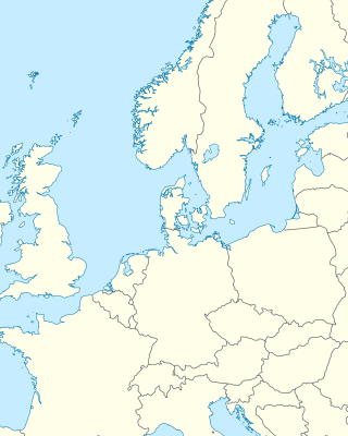
| صورة image | Northern and Central Europe location map.svg
| ||

| |||
وحدة:Location map/data/Northern and Central Europe هي خريطة موقع تستعمل لتركيب علامات وتسميات في an Lambert azimuthal equal-area projection خريطة Northern and Central أوروبا. يتم وضع العلامات بواسطة احداثيات خطي العرض والطول في صورة الخريطة الافتراضية، أو صورة خريطة مماثلة.
الاستخدام
These definitions are used by the following templates when invoked with parameter "Northern and Central Europe":
{{خريطة مواقع|Northern and Central Europe |...}}{{Location map many|Northern and Central Europe |...}}{{خريطة مواقع+|Northern and Central Europe |...}}{{خريطة مواقع~|Northern and Central Europe |...}}
تعريف الخريطة
name = Northern and Central Europe- الاسم المستخدم في التسمية التوضيحية للخريطة الافتراضية
image = Northern and Central Europe location map.svg- الصورة الافتراضية دون "Image:" أو "صورة:" أو "File:" أو "ملف:"
x = ((131.579*( cos( $1*pi/180 )*sin( ($2-10)*pi/180 ) ) * ( ((1 + sin( $1*pi/180 )*sin( 52*pi/180 ) + cos( $1*pi/180 )*cos( 52*pi/180 )*cos( ($2-10)*pi/180 ) ) *0.5)^ -0.5) - (-36.388))*14.0134-200)/6- An expression to calculate a location on the map via its طول جغرافي; evaluates as 0 along the left edge and 100 along the right edge
y = ((55.11 - 153.610*( cos( 52* pi/180)*sin( $1*pi/180 ) - sin( 52*pi/180 )*cos( $1*pi/180 )*cos( ($2-10)*pi/180 ) ) * ( ((1 + sin( $1*pi/180 )*sin( 52*pi/180 ) + cos( $1*pi/180 )*cos( 52*pi/180 )*cos( ($2-10)*pi/180 ) ) *0.5)^ -0.5))*11.9834-174.92)/7.5- An expression to calculate a location on the map via its عرض جغرافي; evaluates as 0 along the top edge and 100 along the bottom edge
أمثلة على استخدام قوالب خريطة الموقع
Location map
{{خريطة مواقع| Northern and Central Europe
| width   = 250
| label   = Hamburg
| lat_deg = 53.57
| lon_deg = 10.00
}}
Location map many
{{Location map many| Northern and Central Europe
| width    = 250
| caption  = Two locations in Europe
| label1   = Trondheim
| lat1_deg = 63.43
| lon1_deg = 10.39
| label2   = Venice
| lat2_deg = 45.44
| lon2_deg = 12.34
}}
Location map+
{{خريطة مواقع+| Northern and Central Europe
| caption  = Two locations in Europe
| width   = 250
| places  =
  {{خريطة مواقع~| Northern and Central Europe
  | label   = Bordeaux
  | lat_deg = 44.84
  | lon_deg = -0.58
  }}
  {{خريطة مواقع~| Northern and Central Europe
  | label   = Rīga
  | lat_deg = 56.95
  | lon_deg = 24.11
  }}
}}
أنظر أيضا
- قوالب خريطة الموقع
- قالب:خريطة مواقع، لعرض علامة واحدة وتسمية باستخدام خطوط الطول والعرض.
- قالب:Location map many، لعرض ما يصل إلى تسع علامات وملصقات.
- قالب:خريطة مواقع+،لعرض عدد غير محدود من العلامات والملصقات.
| هذه صفحة توثيق وحدة:Location map/data/Northern and Central Europe الفرعية، لشرح القالب وتصنيفه، وهي لا تدخل في استخدامه. |

