
ملف:Gaza Strip Access Restrictions.pdf

الملف الأصلي (4٬950 × 7٬085 بكسل حجم الملف: 4٫76 ميجابايت، نوع MIME: application/pdf)
| هذا ملف من ويكيميديا كومنز. معلومات من صفحة وصفه مبينة في الأسفل. كومنز مستودع ملفات ميديا ذو رخصة حرة. |
ملخص
| الوصف |
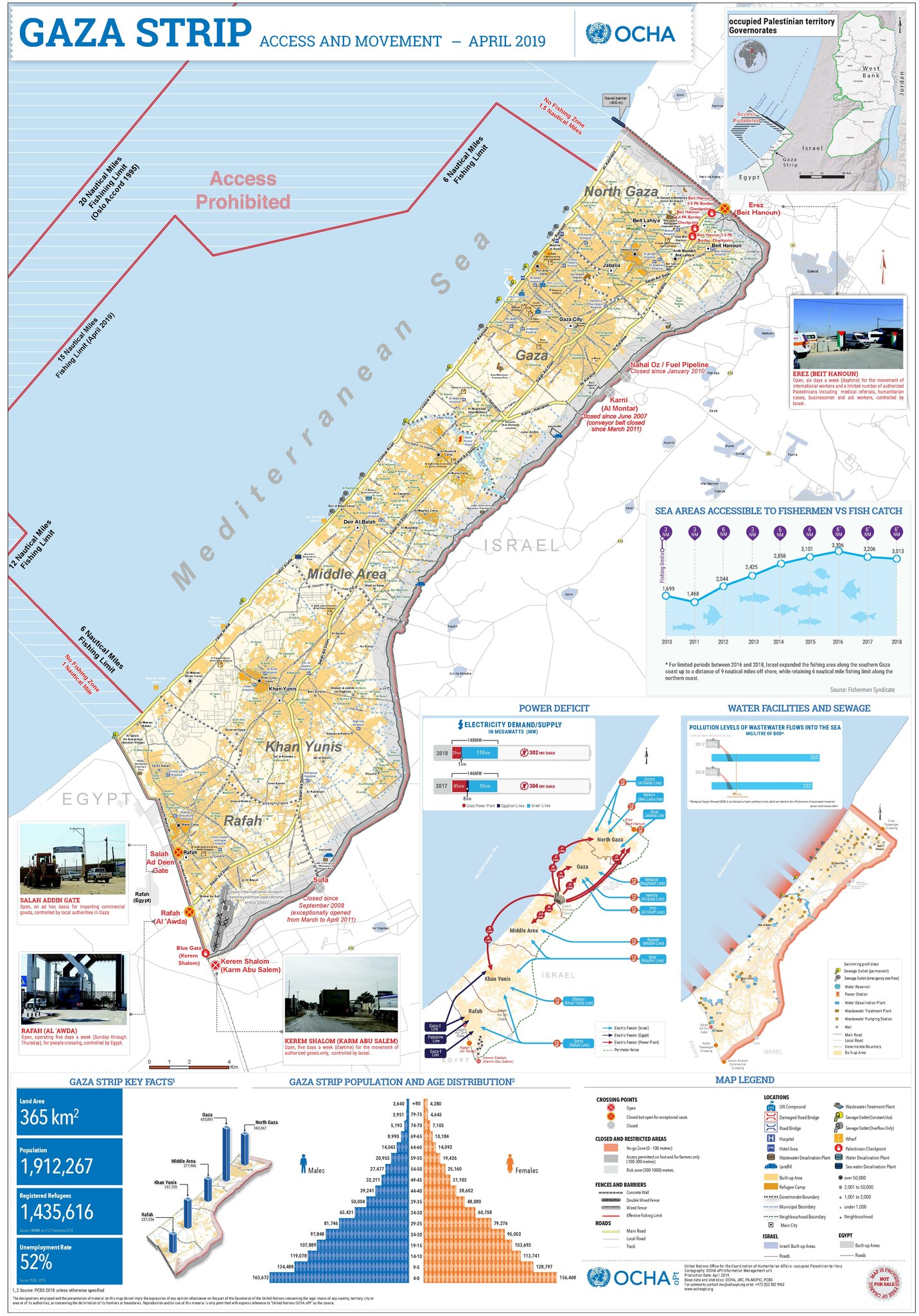
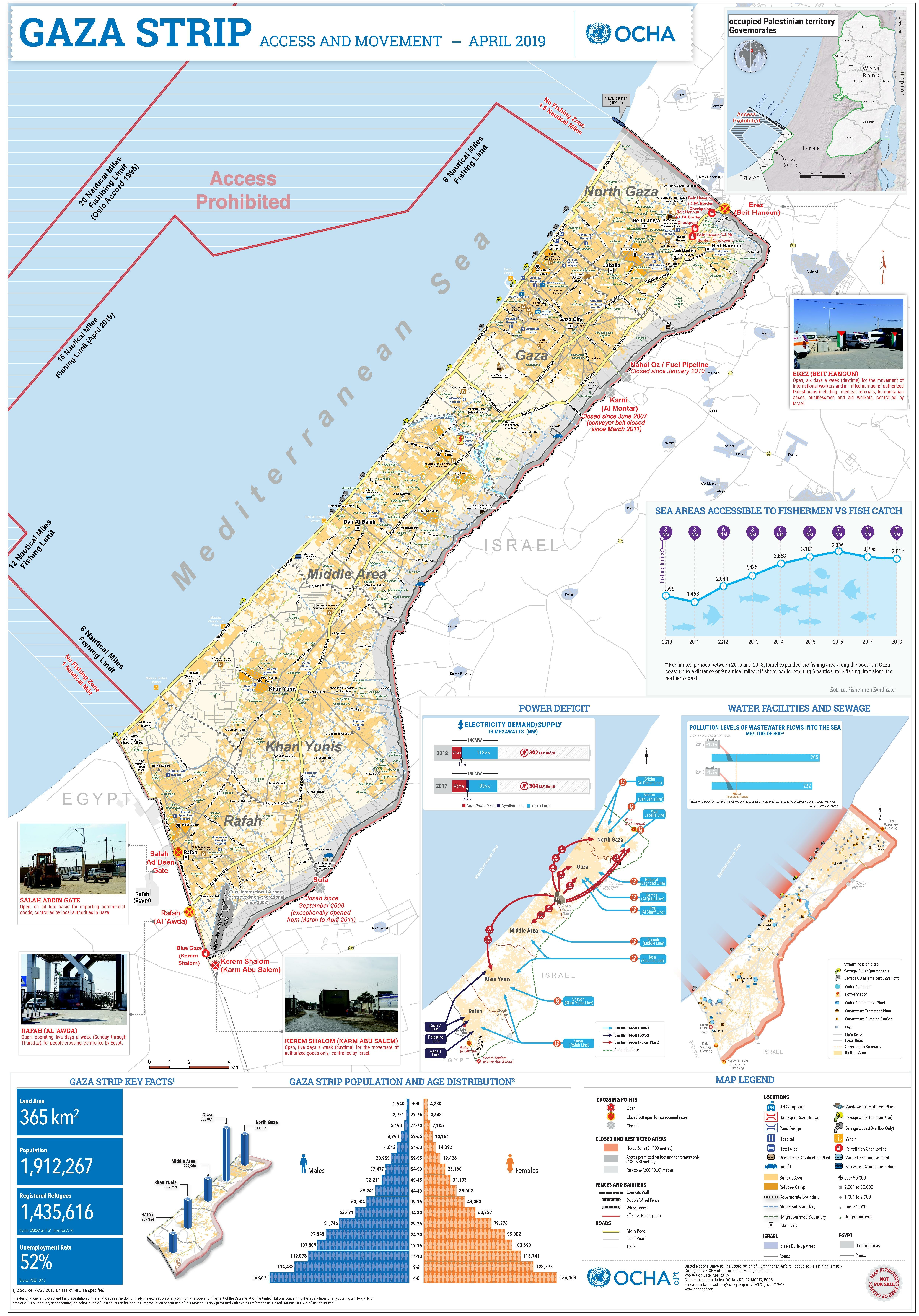
Deutsch: Gazastreifen mit Zugangsbeschränkungen für seine Bewohner
English: A map of the Gaza Strip and the access restrictions its residents have |
|||
| التاريخ | ||||
| المصدر | https://www.ochaopt.org/sites/default/files/Gaza_A0_2023.pdf | |||
| المؤلف | United Nations Office for the Coordination of Humanitarian Affairs (OCHA) | |||
| الترخيص (إعادة استخدام هذا الملف) |
|

تاريخ الملف
اضغط على زمن/تاريخ لرؤية الملف كما بدا في هذا الزمن.
| زمن/تاريخ | صورة مصغرة | الأبعاد | مستخدم | تعليق | |
|---|---|---|---|---|---|
| حالي | 12:13، 12 ديسمبر 2023 |  | 4٬950 × 7٬085 (4٫76 ميجابايت) | Wickey | Reverted to version as of 21:42, 14 December 2020 (UTC). Different image; please put it in a new file |
| 15:27، 8 أكتوبر 2023 |  | 4٬950 × 7٬085 (6٫8 ميجابايت) | Isochrone | 2023 version from https://www.ochaopt.org/sites/default/files/Gaza_A0_2023.pdf | |
| 21:42، 14 ديسمبر 2020 |  | 4٬950 × 7٬085 (4٫76 ميجابايت) | Veggies | {{Information |Description=A map of the Gaza Strip and the access restrictions its residents have |Source=https://www.ochaopt.org/sites/default/files/gaza_a0_press.pdf |Date=2019-05-07 |Author=United Nations Office for the Coordination of Humanitarian Affairs (OCHA) |Permission={{PD-UN-map}} |other_versions= }} |
استخدام الملف
الصفحتان التاليتان تستخدمان هذا الملف:
الاستخدام العالمي للملف
الويكيات الأخرى التالية تستخدم هذا الملف:
- الاستخدام في arz.wikipedia.org
- الاستخدام في az.wikipedia.org
- الاستخدام في bn.wikipedia.org
- الاستخدام في ca.wikipedia.org
- الاستخدام في da.wikipedia.org
- الاستخدام في de.wikipedia.org
- الاستخدام في el.wikipedia.org
- الاستخدام في en.wikipedia.org
- الاستخدام في eo.wikipedia.org
- الاستخدام في es.wikipedia.org
- الاستخدام في eu.wikipedia.org
- الاستخدام في fa.wikipedia.org
- الاستخدام في fi.wikipedia.org
- الاستخدام في fr.wikipedia.org
- الاستخدام في he.wikipedia.org
- الاستخدام في id.wikipedia.org
- الاستخدام في ja.wikipedia.org
- الاستخدام في kk.wikipedia.org
- الاستخدام في ms.wikipedia.org
- الاستخدام في nl.wikipedia.org
- الاستخدام في no.wikipedia.org
- الاستخدام في pap.wikipedia.org
- الاستخدام في sat.wikipedia.org
- الاستخدام في tr.wikipedia.org
- الاستخدام في zh.wikipedia.org