
ملف:Iceberg A22A, South Atlantic Ocean.jpg

حجم هذه المعاينة: 800 × 530 بكسل. الأبعاد الأخرى: 320 × 212 بكسل | 640 × 424 بكسل | 1٬024 × 678 بكسل | 1٬280 × 848 بكسل | 2٬345 × 1٬553 بكسل.
الملف الأصلي (2٬345 × 1٬553 بكسل حجم الملف: 793 كيلوبايت، نوع MIME: image/jpeg)
| هذا ملف من ويكيميديا كومنز. معلومات من صفحة وصفه مبينة في الأسفل. كومنز مستودع ملفات ميديا ذو رخصة حرة. |
ملخص
| الوصف |
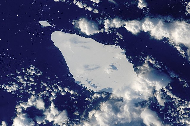
English: This astronaut photograph illustrates the remains of a giant iceberg—designated A22A— that broke off Antarctica in 2002. The iceberg was photographed at a location of 49.9 degrees south latitude, 23.8 degrees west longitude, which is about a third of the distance from South America towards Cape Town, South Africa. A22A is one of the largest icebergs to drift as far north as 50 degrees south latitude, bringing it beneath the daylight path of the International Space Station (ISS). Crew members aboard the ISS were able to locate the ice mass and photograph it, despite the great masses of clouds that often accompany winter storms in the Southern Ocean. The crew’s viewing angle was oblique (not looking straight down) from a point to the west of the berg, and the time of day was early afternoon, as shown by the orientation of the cloud shadows. Dimensions of A22A in early June were 49.9 by 23.4 kilometres, giving it an area of 622 square kilometres, or seven times the area of Manhattan Island.
|
||||||||||||||||||||||||||||||||||||||||||||||||||
| التاريخ | |||||||||||||||||||||||||||||||||||||||||||||||||||
| المصدر | {{URL|example.com|optional display text}} | ||||||||||||||||||||||||||||||||||||||||||||||||||
| المؤلف | Image provided by the ISS Crew Earth Observations experiment and the Image Science & Analysis Laboratory, NASA - Johnson Space Center. | ||||||||||||||||||||||||||||||||||||||||||||||||||
| موقع الكائن | | هذه وغيرها من الصور في مواقعها على: خريطة الشارع المفتوحة |
|---|
فُهرِست هذه الصُّورة أَو هذا التَّسجيل المرئي لدى مركز جونسون للفضاء التَّابعة لوكالة الفضاء الأَمريكيَّة (ناسا) تحت المُعرِّف ISS015-E-10125. لا يُشير هذه الوَسم إلى حالة حقوق التَّأليف والنَّشر الخاصَّة بالعمل المُرفَق؛ لا يزال وَسم حقوق التَّأليف والنَّشر مَطلُوباً، راجع كومنز:ترخيص لمزيدٍ من المعلومات. لغات أخرى:
|
ترخيص
| يقع هذا العمل في النِّطاق العامّ في الولايات المُتحدة الأمريكيَّة لأَنَّه عملٌ خالِصٌ من إِنتاج وكالة الفضاء الأمريكيَّة. تنصُ حقوق التَّأليف والنَّشر الخاصَّة بوكالة الفضاء الأمريكيَّة على أنَّ "أعمال الوكالة غير مَحميَّة بحقوق التَّأليف والنَّشر ما لم يُذكر خلافُ ذلك". لمزيدٍ من المعلومات انظر القالِب {{PD-USGov}} وصفحة حقوق التَّأليف والنَّشر الخاصَّة بالوكالة وصفحة سياسة الصُّور الخاصَّة بمُختبر الدَّفع النَّفَّاث. | ||
 |
تنبيهات:
|
تاريخ الملف
اضغط على زمن/تاريخ لرؤية الملف كما بدا في هذا الزمن.
| زمن/تاريخ | صورة مصغرة | الأبعاد | مستخدم | تعليق | |
|---|---|---|---|---|---|
| حالي | 15:25، 22 مارس 2013 | | 2٬345 × 1٬553 (793 كيلوبايت) | Julian Herzog | Higher resolution and quality |
| 19:54، 5 يوليو 2009 |  | 1٬000 × 1٬000 (376 كيلوبايت) | Originalwana | {{Information |Description={{en|1=This astronaut photograph illustrates the remains of a giant iceberg—designated A22A— that broke off Antarctica in 2002. The iceberg was photographed at a location of 49.9 degrees south latitude, 23.8 degrees west lon |
استخدام الملف
الصفحة التالية تستخدم هذا الملف:
الاستخدام العالمي للملف
الويكيات الأخرى التالية تستخدم هذا الملف:
- الاستخدام في az.wikipedia.org
- الاستخدام في bn.wikipedia.org
- الاستخدام في cy.wikipedia.org
- الاستخدام في en.wikipedia.org
- الاستخدام في eo.wikipedia.org
- الاستخدام في it.wikipedia.org
- الاستخدام في it.wikibooks.org
- الاستخدام في it.wikiversity.org
- الاستخدام في la.wikipedia.org
- الاستخدام في mk.wikipedia.org
- الاستخدام في pt.wikipedia.org
- الاستخدام في sl.wikipedia.org
- الاستخدام في ta.wikipedia.org
- الاستخدام في ta.wiktionary.org
- الاستخدام في th.wikipedia.org