
ملف:Land Use in the Potomac Basin.gif
حجم هذه المعاينة: 800 × 598 بكسل. الأبعاد الأخرى: 320 × 239 بكسل | 640 × 479 بكسل | 900 × 673 بكسل.
الملف الأصلي (900 × 673 بكسل حجم الملف: 232 كيلوبايت، نوع MIME: image/gif، 0٫2ث)
| هذا ملف من ويكيميديا كومنز. معلومات من صفحة وصفه مبينة في الأسفل. كومنز مستودع ملفات ميديا ذو رخصة حرة. |
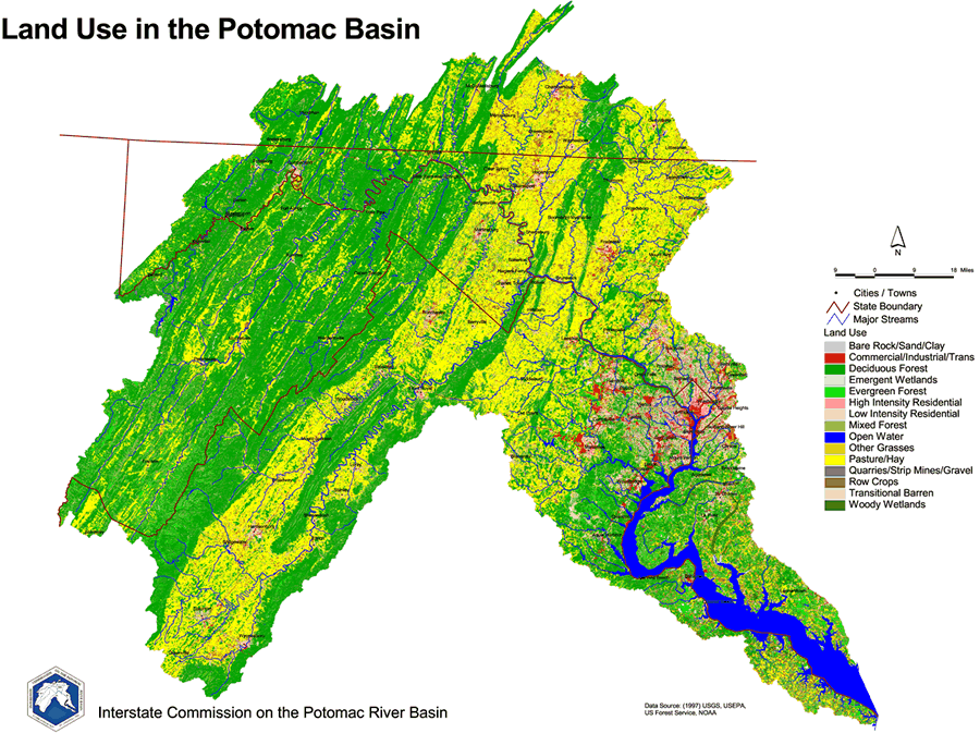
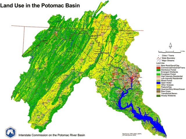
English: 1997 Land Use Map of the Potomac River Basin provided to the public domain by the U.S. Department of the Interior and the U.S. Geological Survey.
تقع هذه الصُّورة في النِّطاق العامّ لأنَّها تحتوي مواد حصريَّة مِن إِنتاج هيئة المساحة الجيولوجيَّة الأمريكيَّة في وزارة الداخلية في الولايات المُتحدة الأمريكيَّة. للمزيد مِن المعلومات انظر سياسية حقوق التَّأليف والنَّشر في موقع هيئة المساحة الجيولوجيَّة الأمريكيَّة الرسميَّة.
|
تاريخ الملف
اضغط على زمن/تاريخ لرؤية الملف كما بدا في هذا الزمن.
| زمن/تاريخ | صورة مصغرة | الأبعاد | مستخدم | تعليق | |
|---|---|---|---|---|---|
| حالي | 19:44، 20 مارس 2006 | | 900 × 673 (232 كيلوبايت) | West Virginian | 1997 Land Use Map of the Potomac River Basin provided to the public domain by the U.S. Department of the Interior and the U.S. Geological Survey. {{USGS}} |
استخدام الملف
الصفحة التالية تستخدم هذا الملف:
الاستخدام العالمي للملف
الويكيات الأخرى التالية تستخدم هذا الملف:
- الاستخدام في azb.wikipedia.org
- الاستخدام في de.wikipedia.org
- الاستخدام في el.wikipedia.org
- الاستخدام في en.wikipedia.org
- الاستخدام في es.wikipedia.org
- الاستخدام في gl.wikipedia.org
- الاستخدام في ja.wikipedia.org
- الاستخدام في ko.wikipedia.org
- الاستخدام في la.wikipedia.org