المرتفعات الأردنية: الفرق بين النسختين
إنشاء موضوع |
(لا فرق)
|
نسخة 16:47، 20 نوفمبر 2021
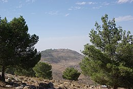
المرتفعات الأردنية (بالإنجليزية: Jordanian Highlands) هي سلسلة جبال في الأردن. تمتد شمالاً وجنوباً عبر الجزء الغربي من البلاد بين منخفض البحر الأبيض غرباً وهضبة في الشرق. المناطق المرتفعة هي موطن لمعظم سكان الأردن والمدن الكبيرة.
جغرافيا
تمتد المرتفعات الأردنية حوالي 300 كيلومتر من الشمال إلى الجنوب. يحد المرتفعات من الشمال وادي نهر اليرموك الذي يشكل جزءًا من الحدود بين الأردن وسوريا. تمتد إلى الجنوب حتى حدود الأردن مع السعودية. من الهضبة إلى الشرق تظهر المرتفعات كسلسلة من التلال. إلى الغرب ، تنخفض المرتفعات بشدة 1000 متر أو أكثر إلى أخدود وادي الأردن، الذي يحتوي على نهر الأردن والبحر الميت، بحيرة مالحة ذات سطح تحت مستوى سطح البحر.[1]
ويتراوح ارتفاع القمم العليا من أكثر من 1200 متر في الشمال إلى 1700 متر في جبل مبارك في الجنوب. وتقطع المرتفعات عدة أودية بين الشرق والغرب، أو أودية، نحتتها تيارات دائمة أو متقطعة. تصب الوديان الشمالية في نهر الأردن الذي يتدفق جنوبا إلى البحر الميت. تفرغ الأودية الجنوبية في وادي عربة، والتي تتدفق شمالًا إلى البحر الميت.[1]
المرتفعات مقسمة إلى ثلاثة أجزاء رئيسية. يُطلق على الجزء الشمالي اسم سواد الأردن، "الأرض الصالحة للزراعة في نهر الأردن"، ويقع بين نهر اليرموك في الشمال ونهر الزرقاء في الجنوب. كلا النهرين روافد لنهر الأردن. إربد، ثاني أكبر مدن الأردن، وعجلون هما أكبر المدن في هذا الجزء.[2]
الجزء المركزي هو مرتفعات البلقاء التي تمتد من نهر الزرقاء جنوبا إلى وادي الموجب. وادي الموجب يصب في البحر الميت. عمان، عاصمة الأردن وأكبر مدينة في المرتفعات، تقع في هذا الجزء، وكذلك بلدتا السلط ومادبا.[2]
The central portion is the Balqa Heights, which extend from the Zarqa River south to Wadi al-Mujib. Wadi-al-Mujib empties into the Dead Sea. عمان (مدينة), Jordan's capital and largest city and the largest city in the highlands, is in this portion, as are the towns of السلط and مادبا.[2]
The southern portion is called the جبال الشراة or Jabal al-Sharat. الكرك is the largest city in this portion, near the southern end of the Dead Sea. The ancient city of البتراء is also in this portion of the highlands, on the western side of the highlands facing Wadi Araba.[2]
Geology
The highlands were formed by relatively recent (العصر النيوجيني–العصر الرباعي) tectonic events, as the northwestern rim of the الصفيحة العربية was uplifted as it moves northward and clockwise.[1]
Climate
The climate of the Highlands ranges from north to south and with elevation. Towards the north and west and at higher elevations a مناخ متوسطي prevails, with mild rainy winters and hot, dry summers. A desert climate prevails towards towards the east and south and at lower elevations. The rainy season extends from October to May, with the heaviest rainfall between November and March. Rainfall ranges from 600 mm annually in the northern mountains to 50 mm in the southernmost highlands and the eastern desert plateau.[3]
Ecology

The western slopes and highest elevations are semi-arid to semi-humid, with average annual rainfall of 350 mm or more. The natural vegetation was Mediterranean forest, woodland, and scrub, occurring above 700 meters elevation in the northwest, and between 900 and 1700 meters elevation in the southwest. Forests and open woodlands are found in the northern and southern parts of the highlands. Trees in the northern forests include صنوبر حلبي (Pinus halepensis), evergreen oaks (بلوط قلبريني, بلوط صبغي, and سنديان فش), and قطلب عثكولي. Forests and woodlands in the southern highlands include Quercus calliprinos, cypress (سرو المتوسط), juniper (عرعر فينيقي), and pistachio (بطم أطلسي). In the southern forests and woodlands oaks are found on limestone-derived soils, with open woodlands of juniper growing over sandstone. In the southern highlands there are shrublands of wild hawthorn (زعرور شائع), almond (لوز), and pistachio, and acacia woodlands with سنط ملتوي and سنط ملتوي in the transition zone between the forests and woodlands and the lower-elevation steppe.[4] The forests and woodlands have been reduced in area and degraded by centuries of deforestation and over-grazing by livestock.[3][4]
A semi-arid steppe zone lies between 600 and 800 meters elevation on the eastern slope of the mountains, where rainfall is between 200 and 350 mm annually.[3] In the drier southern mountains the eastern steppe zone extends up to 1100 or 1200 meters elevation. There is a narrower steppe zone on the western slopes between the upper-elevation Mediterranean forests and the lower-elevation deserts of the Jordan Rift Valley. Predominant steppe plants are low shrubs, particularly شيح أبيض, and grasses.[4]
Desert vegetation is found in the Jordan Rift Valley, the southern highlands, and the eastern plateau. where average annual rainfall is 200 mm or less.[3]
See also
References
- ^ أ ب ت ث Wagner W. (2011) Northwestern Mountain and Rift Zone of the Northern Arabian Platform. In: Groundwater in the Arab Middle East. Springer, Berlin, Heidelberg. دُوِي:10.1007/978-3-642-19351-4_2
- ^ أ ب ت ث Shoup, John A. (2007). Culture and Customs of Jordan. Greenwood Press, 2007. (ردمك 9780313336713), 0313336717
- ^ أ ب ت ث Abu-Sharar T. (2006) THE CHALLENGES OF LAND AND WATER RESOURCES DEGRADATION IN JORDAN: DIAGNOSIS AND SOLUTIONS. In: Kepner W.G., Rubio J.L., Mouat D.A., Pedrazzini F. (eds) Desertification in the Mediterranean Region. A Security Issue. NATO Security Through Science Series, vol 3. Springer, Dordrecht. دُوِي:10.1007/1-4020-3760-0_08
- ^ أ ب ت Willimott, S.G., Birch, B.P., McKee, R.F., Atkinson, K., and Nimry, B.S. (1964). "Conservation Survey of the Southern Highlands of Jordan".

